360°: StreetView mapping
CHF2,350.00
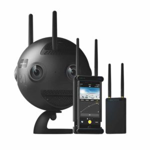
Medium- to large-scale streetview capture, using automated system allowing to capture 360° images at defined interval.
All 360° panoramas as automatically tagged with GPS data, so they can easily be integrated into GIS application or other monitoring tools.
The camera is mounted on top of a mobile platform (vehicle, conveyor, dolly,…) and possibly rigged with mobile lighting solution, as to ensure quality captures even in dark areas.
Due to the nature of such survey and mapping assignments, project coordination is often required before a proper offer can be made.
Please contact GlobalVision for more details.
Description
Système complet de capture mobile d’images panoramiques.
Capture d’images 360° avec géo-positionnement (références NMEA).
Intégration d’informations sur le positionnement dans l’image (EXIF, KML, et/ou fichier texte).
————
Complete mobile-mapping system with panoramic imagery capability.
Capture of 360° panoramas with full GPS positionning of images (NMEA format).
Embedding of position data in images’ EXIF data, KML and/or with text file.